The South Idaho Park N’ Ski area is a great place to stay and play. The trails in this area are used to access the Idaho City Backcountry Yurt System.
For Mores Creek Summit conditions, visit https://www.nwrfc.noaa.gov/snow/snowplot.cgi?MRKI1.
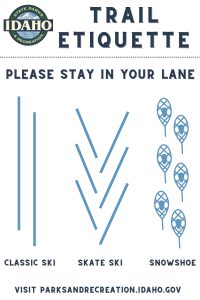
Remember, this is a multi-use trail system open to skiers, snowshoers, fat-tire bikers, and hikers. Please preserve the tracks for skiers by utilizing the trail lane intended for your user group.

Current Snow Conditions
For updates on grooming status and trail conditions: visit the Idaho Non-Motorized Trails Program Facebook page.
https://www.facebook.com/IdahoNonMotorizedTrailsProgram
| Details | Beaver Creek Summit Park N' Ski |
|---|---|
| Location | 25 m N of Idaho City off Hwy 21 |
| Difficulty | Intermediate - Advanced |
| Distance | 3 m |
| Grooming | No |
| Snowshoeing | Yes |
| Yurt | Yes - Stargaze Yurt |
| Backcountry ski potential | Yes - fabulous! |
| Restroom | No |
| Dogs | Yes |
| About | This ungroomed out-and-back trail is designed especially for backcountry Nordic folks, whether on skis or snowshoes. You'll understand how it got its name after you make your way to the top of Stargaze Point (1.5 miles one way) where you'll find a 360 degree view of the Boise National Forest that includes Pilots Peak, Wilson Butte, Sunset Peak, Rock Creek and Scott Mountain. At over 6,500 feet, it's the perfect Telemark skiing on many north and west facing slopes where there is deep powder most winter seasons. |
| More Information | Non-Motorized Trails Facebook |
| Parking | The Park N' Ski parking lot is just before the snowplow turn around on the left side of Hwy 21, about 300 yards before the Beaver Creek Summit. Do not park in the snowplow turn around parking lot. From the parking lot ski/snowshoe along the shoulder of Hwy 21 for about 300 yards until you reach the highest point, Beaver Creek Summit. At the summit turn left on an old road bed marked with a sign post saying "Stargaze Trail." |
| Maps | Beaver Creek Summit trail map Beaver Creek Summit location map Beaver Creek Summit Winter Parking Rules |
| Details | Banner Ridge Park N' Ski |
|---|---|
| Location | 23 m N of Idaho City off Hwy 21 |
| Difficulty | Intermediate - Advanced |
| Distance | 22 m/35.4 km |
| Grooming | Yes - set track for traditional kick and glide |
| Snowshoeing | Yes |
| Yurt | Yes - Banner Ridge and Elkhorn Yurts |
| Backcountry ski potential | Yes |
| Restroom | Yes |
| Dogs | Yes on ungroomed trails only |
| About | If you like to crank out the miles on your skis, backcountry ski or cruise around on snowshoes either on-trail or off-trail, the Banner Ridge area is packed with opportunity and fun. It's a pretty steep 1.3-mile climb from the trailhead to the ridge, but once you're on top, there are many loops, big views and open bowls to enjoy from there. |
| More Information | Non-Motorized Trails Facebook |
| Maps | Banner Ridge trail map Banner Ridge location map Banner Ridge Winter Parking Rules |
| Details | Gold Fork Park N' Ski |
|---|---|
| Location | Location 20 miles north of Idaho City off Highway 21 |
| Difficulty | Beginner - intermediate |
| Distance | Total 21.4 m/34.4 km; Gold Fork Loop - 5.1 m /8.2 km; Skyline Loop 4 m/6.4 km |
| Grooming | Yes - set for traditional kick and glide |
| Snowshoeing | Yes |
| Yurt | Yes - Whispering Pine and Skyline Yurts |
| Backcountry ski potential | Yes on the Gold Fork side |
| Restroom | Yes |
| Dogs | Yes on all trails |
| About | The Gold Fork Park N' Ski area provides access to two complete trail systems on either side of Hwy 21. One trail tours the Gold Fork area, the other loops the Skyline area and connects to the greater Banner Ridge/Beaver Creek trail systems. A separate ungroomed snowshoe trail tours a ridge in the Gold Fork area. There's also a short snowshoe trail from the Skyline yurt. This is a great place to take kids for an easy, low key outing. |
| More Information | Non-Motorized Trails Facebook |
| Maps | Gold Fork trail map Gold Fork location map Gold Fork Winter Parking Rules |
| Details | Whoop-Um-Up Park N' Ski |
|---|---|
| Location | 18 m N of Idaho City on Hwy 21 |
| Difficulty | Beginner - intermediate |
| Distance | 6.6m/10.6km ski trails |
| Grooming | No |
| Snowshoeing | Yes |
| Yurt | Yes - Rocky Ridge Yurt |
| Backcountry ski potential | No |
| Restroom | Yes |
| Dogs | Yes |
| About | Snowshoers with dogs love Whoop-Um-Up because this is one of the areas where dogs are welcome. Dogs are also welcome in the Rocky Ridge yurt. Be aware that the parking area is shared with snowmobiles, so you will encounter snow machines as you gear up for your adventure. Trails can be a bit rugged in this area with a few steep and challenging downhill sections along the creek trail. |
| More Information | Non-Motorized Trails Facebook |
| Maps | Whoop-Um-Up trail map Whoop-Um-Up location map Whoop-Um-Up Parking Guide |
ver: 3.5.2 | last updated:


